
Genghis Khan reopened the Silk Road. Julius Caesar brought Gaul into the Roman economy. Alexander the Great forged the Hellenistic world, a cosmopolitan, Greek-speaking culture that linked cities around the Mediterranean. Conquerors have always created new trade patterns and altered economies. By mere fact of bringing large numbers of people across continents—soldiers, craftsmen, merchants, families—they create new connections across enormous distances.
But war and conquest are not the only things that turn the world from age to age. The systems of trade that they bring in their wake are also forces unto themselves, changing the structure of human society on their own, longer timescale. Of these, one of the most significant in world history was the monsoon trade system, which dominated the entire Indian Ocean from Antiquity to the modern era. It was the wind-powered highway that carried goods from China to Rome, as well as the communication network that spread religion, philosophy, and science in the Middle Ages.
It did not spring into being spontaneously, but was the result of deliberate exploration by men; in the ever-recursive cycle of human events, their discoveries may too have had their ultimate origins in war. If so, it was not conquest, but an enormous military disaster that might have set the great trade system in motion.
To India on a Storm Cloud
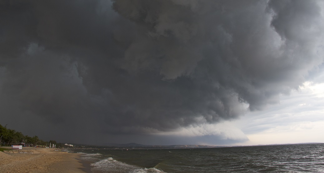
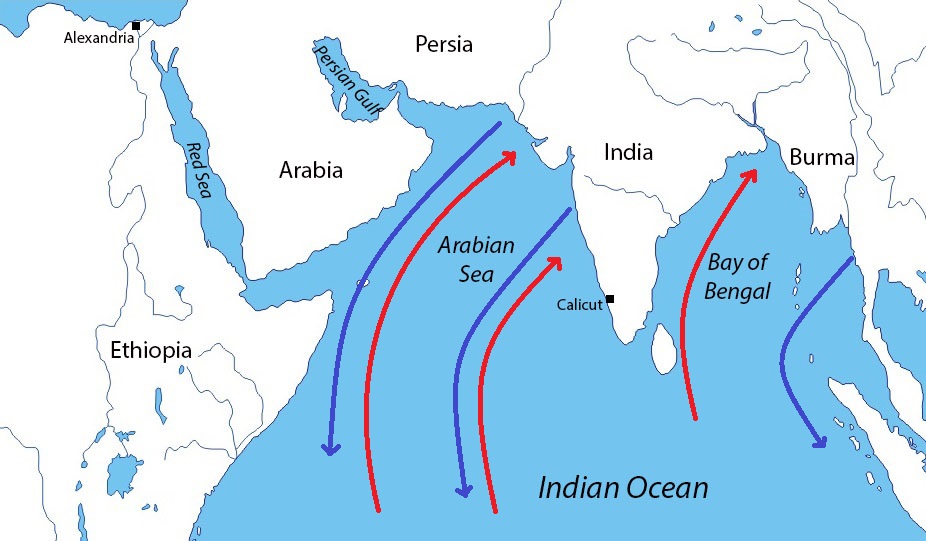
The monsoon trade system was driven by the seasonal storm winds, which allowed sailors to travel vast distances in a matter of weeks. In the western half of the ocean, monsoon winds pick up out of the southwest beginning in late May and continue to blow through the summer. In late fall, the cycle reverses itself, and the winds come from the northeast. This two-way pattern allowed sailors quickly sail from the Red Sea to India and back in the same year. In the Bay of Bengal, in the eastern half of the ocean, these wind patterns are mirrored, which allowed merchants from eastern India and Burma to quickly reach the Strait of Malacca and the Spice Islands beyond.
Indian Ocean trade did not always follow the monsoon winds. Before that technique was discovered, sailors were constrained to following the coast. Merchants departing from the Red Sea made their way up the southeast coast of Arabia then across the Strait of Hormuz to the southern coast of Persia, which they would follow all the way to the Indus River. The last part was one of the most barren and desolate stretches in the known world, inhabited by wild, dangerous people known to the Greeks only as “fish-eaters.” Intermittent streams along the coast provided water during the wet season, but it was otherwise hostile to human life.
It was probably in the 1st century BC that a pilot named Hippalus discovered the open-water route. The story is related in the Periplus of the Erythraean Sea, a catalogue of all the locales bordering the Red Sea and the western Indian Ocean: Hippalus, who from long experience knew the geographic relation of all the ports between the Red Sea and the Indus, understood that sailing northeast would take him directly to India. Realizing that the southwest monsoon winds could carry him straight across, one spring he set a course from Arabia out into the ocean, returning at the end of the season to tell the tale.
Once the open-water route was discovered, the riches of the Indian trade drew swarms of merchants to risk the open waters. Those who did were richly rewarded by the sybaritic elites of the Hellenistic kingdoms, who competed with one another in their ostentatious displays of luxury. Soon Hellenistic royal houses were displaced by an even richer power: Rome. Romans’ insatiable demand for silk, spice, and other finery drove sailors to make the Indian Ocean crossing in ever-increasing numbers, turning the seasonal adventure into an industry.
Nor was this a simple two-way flow of silver in one direction, spices in the other. Travel by monsoon winds drew several regional trade networks into one integrated system: gold and ivory from East Africa, incense from Arabia, spices from India and Southeast Asia, and silk from China. This initial demand spurred the growth of a self-sustaining system that spanned thousands of miles across the vast ocean and endured a millennium after the fall of Rome.
Origin of the Discovery
In one sense, it is obvious how Alexander had a role in the creation of the monsoon trade system. He conquered Egypt, which was ruled by the Ptolemies after his death. Their kingdom was the major emporium connecting the Mediterranean with the Red Sea, and Hippalus’ home port was likely on Egypt’s Red Sea coast.
Alexander also brought Greeks into direct contact with India for the first time. Although Herodotus had recounted stories about India a hundred years earlier and individual Greek travelers had doubtlessly made their way there, the Macedonian conquests were the first time that large numbers of Greeks encountered the subcontinent. Many of them wrote accounts of their travels which circulated around the Greek-speaking world, spurring men’s imaginations and their greed. So great were the rewards that men took huge risks to make the voyage; how much greater risks would they take if they could make the trip in a matter of weeks?
Imagine being the first person to make the Indian Ocean crossing. In an age when sailors rarely ventured far from land, it required sailing straight out into the ocean, catching the winds (depending on when in the season you departed, they could be quite violent), and sailing on open waters for over a month. You would be putting not just your own life at risk, but also the lives of your crew. It was a daring move that only someone with vast, first-hand experience would attempt. It is possible that Hippalus was not just relying on his own knowledge of the coasts, however. The Greeks of the Hellenistic Era knew a surprising amount about geography that undoubtedly helped Hippalus. There was one famous incident, however, well known to all Greeks of the era, that may have provided the clue that made his journey possible.
Alexander’s Deadliest Foe
The incident relates to the worst disaster to befall Alexander, one which was said to destroy most of his army. This was the crossing of the Gedrosian Desert, the harsh wasteland on the interior of the Makran Coast which the Macedonians traversed on their return from India to Persia.

The Macedonian army had already endured some of the world’s most brutal climates up to that point. It had crossed the open sands of the Egyptian desert, traversed the ice-choked, wind-blasted passes of the Zagros Mountains, skirted the endless salt flats of the Dasht-e Kavir, and fought its way across the Bactrian Desert, where summer temperatures were so high that even locals did not go outside during the day. Of all these, the Gedrosian Desert was by far the worst.
After deciding to depart India in 325 BC, Alexander sailed his army south down the Indus River. Once he reached the ocean, he split his forces into two: the army would march along the coast, while the fleet would sail parallel. The ships were loaded with sufficient food for the entire expedition, and Alexander timed their departure so that the monsoon rains would flood the streams along the coast, giving them enough fresh water. What he did not account for were the winds that accompanied the monsoon rains.
Alexander set off with the army in mid-July to subdue the last remaining fertile lands before the Gedrosian Desert. The fleet was scheduled to follow a few weeks later, but the monsoon winds continued to blow, trapping the ships in harbor until October. Alexander took his men to the assigned rendezvous point on the coast, but the fleet never showed. Running low on provisions, Alexander was forced to make a decision: stick around and wait, return the way they had come through country that had already been stripped of supplies, or continue on. Seeing no other option, Alexander pressed forward. It was impossible to follow the planned coastal route, where fish was the only available food, sufficient to support a scant population. Instead, he turned inland to the Gedrosian Desert.
The sand was so hot that it burned through men’s sandals. Winds whipped up the burning sands, which cut through garments and lacerated the skin. Water could be found, but it was scarce, and when it was found, men would often die from drinking to excess. The army was able to requisition some nomads’ flocks, but not enough to feed everyone; men turned to eating the horses and mules that died from exhaustion, getting sick themselves from the uncooked meat.
The story is stunning in many ways. Alexander was always a meticulous planner, and his army rarely faced shortages of food even when passing through the most inhospitable lands. No man had ever defeated him, but the forces of nature succeeded in nearly wiping out his army—three quarters of his men died, by one account. Ancient writers came up with different reasons to account for Alexander’s failure: he was trying to punish his troops for insisting on returning from India, or he was driven by hubris to follow a route taken by Cyrus the Great. Few seemed to recognize how the awesome forces of nature forced him into taking such a dangerous course.

Any sailor who had made the trip to India would have immediately understood Alexander’s predicament. Two points in particular would have jumped out at him: the unforgiving nature of the Makran Coast and the unrelenting strength of the monsoon winds. Sailors, too, had to contend with the tricky problem of timing their departure, as they had to sail when the winds were not too strong but when the season was still wet enough to provide sufficient water. Could Alexander’s problem, and thus theirs, have had an easier solution?
The Library at the Center of the World
The Periplus credits Hippalus as the man who made the first voyage across the Indian Ocean, but he was not necessarily the first to realize the monsoon’s potential. On the one hand, he was an experienced navigator who knew the coastal route to India very well, including sailing times and approximate directions between ports. He could have possibly reconstructed a large-scale picture of the Indian Ocean from this knowledge alone. On the other hand, his entire sense of space would have been the relations between adjacent ports, which does not necessarily make it easy to visualize the overall geometry. If Hippalus himself was not able to do this himself, there was a certain group of men who most certainly were able to.

The Greeks of the Hellenistic Age lived in an incredible time. The centuries following the death of Alexander saw an incredible explosion of human knowledge in which the number of discoveries in mathematics, astronomy, and geography surpassed anything before the modern era. Nor were these just intellectual discoveries, but practical inventions: piston pumps, the Archimedean screw, repeating ballistas, and complex machines involving gears and pulley systems. Men in Alexandria, Pergamum, and Rhodes who blurred the line between academics and practitioners fed off one another’s work—the spirit of discovery was infectious.
Alexandria was especially important as the capital of the Kingdom of Egypt, founded by Ptolemy I in the wars following Alexander’s death. Ptolemy and his successors patronized the great Library of Alexandria, a combination of library and university. There they gathered texts from the Greek-speaking world and surrounding lands, to include anything that might be useful, such as mathematics, agriculture, geography, alchemy, as well as religious and literary works—the mere fact of assembling so many texts in one place probably accounts for much of the advance in knowledge. This storehouse of knowledge attracted the greatest scholars of the age, who produced the largest share of the discoveries and inventions of the Hellenistic Age.
One man in particular contributed an enormous amount: Eratosthenes of Cyrene (276-195 BC). He is most famous today for being the first to accurately measure the circumference of the earth, to within 15%, but he was even better known in the ancient world as a geographer and mathematician. He wrote a now-lost book of geography, in which he introduced map grids and used astronomical techniques, taken from his measurement of the earth’s circumference, to estimate the latitude of geographical locations. In the century after his death, geographers such as Hipparchus and Posidonius refined his techniques and measurements.
Astronomy could be used to estimate a latitude, but not a longitude. For that, direct measurements were necessary, meaning geographers had to look to another source. Fortunately, they had at their disposal excellent sources: accounts of Alexander the Great.
Walking to the End of the World
Histories of the Macedonian conquests were not just plain narratives events. Alexander’s army was accompanied by specialists of all kinds who collected information on the peoples and places they encountered, ultimately providing a wealth of knowledge for Hellenistic Age geographers. The army was also accompanied by a certain kind of technician called bematists. These were pace-counters who were responsible for tracking the distances the army traveled based on the length of their stride. Their estimates were extremely accurate, within 3% of modern measurements on average.
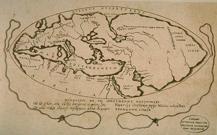
Just before Alexander’s death, he sent several fleets to explore the Arabian coast in preparation for further conquests. The results of this survey and the bematists’ measurements, along with the numerous accounts of mariners who had passed by those shores in the years since, allowed geographers to piece together a fair idea of Indian Ocean coastline between the entrance to the Red Sea and the mouth of the Indus River. Combined with the astronomical measurements, they could produce a pretty accurate map.
The ancient geographers would have found the histories of Alexander fascinating, but the disaster in the Gedrosian Desert would have transfixed their attention. Alexander was something close to a god to the Greeks of the Hellenistic Age, the progenitor of their entire Mediterranean-spanning civilization; for him to have failed so spectacularly must have meant that he aroused the wrath of the gods. And in this case, the gods’ vengeance came in the form of monsoon winds.
As far removed from the Indian Ocean as the great Hellenistic geographers were, they would have been fascinated by the monsoon. In general, they were obsessed by questions of geographical phenomena: the relation between the moon and the tides, the causes of weather, and the source of the Nile. It was only natural for them to ask similar questions about the monsoon: what caused it, what path it took, and so forth. They could easily chart the wind currents at various points (which shift course across the Indian Ocean, blowing to the north-by-northeast up the African coast before shifting to the east in the Arabian Sea) by taking observations of the prevailing wind direction at either end of the route, then extrapolating for points in between. With such an image in hand, it would be a short leap to imagine that a ship could exploit the monsoon.
Therefore, we can wonder: perhaps someone at the Library of Alexandria was the first to realize that the monsoon winds could be used to reach India. Geographers could have speculated a possible course which Hippalus’ experience validated, leading him to undertake such a daring voyage of discovery. If so, there is a striking parallel that occurred 1,500 years later.
Around the Southern Cape
When the Portuguese made their bid to sail to India in the 15th century, it was a decades-long effort. Their monarchs began by funding numerous exploratory voyages down the African coast, setting up trade outposts as they went to provision subsequent expeditions. At the same time, they assembled a formidable group of experts in Lisbon—astronomers, cartographers, engineers, and shipwrights—in order to collate the information from each expedition and use it to plan future ones.
Through this deliberate effort, the Portuguese were able to get an accurate understanding of the wind systems of the Atlantic Ocean. For instance, once ships sailed past the Gulf of Guinea (south of the continent’s western bulge), they hit a double obstacle. First, they sailed through the doldrums, the latitudes around the equator where there is little wind. Then, once past the Congo River, they ran into strong countervailing winds that made progress slow. A mishap during Bartolomeu Dias’ 1487 expedition filled out the picture: near the Cape of Good Hope, a storm blew him out into the ocean. There, he caught westerly winds that carried him east then northeast, where he made landfall beyond the southernmost tip of Africa.
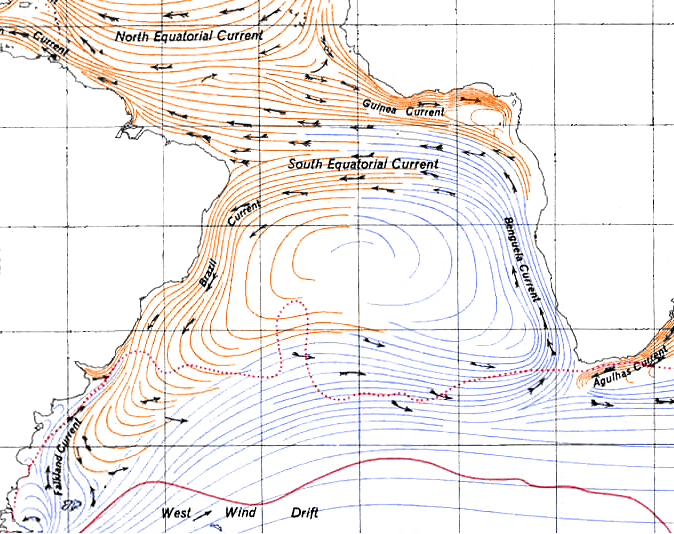 From this, the men in Lisbon were able to deduce that the wind patterns south of the equator must mirror those north, blowing counterclockwise instead of clockwise. Based on these conclusions, Vasco da Gama took an extraordinary leap of faith on his voyage to India in 1497. Rather than follow the coastline east across the Gulf of Guinea, he jagged southwest into the Atlantic Ocean; there, he picked up the South Atlantic gyre—the hypothesized, but as yet unseen, wind pattern—which carried him south just a few hundred miles off the coast of Brazil, then east to the Cape of Good Hope. The voyage up to that point took four months, two months shorter than it had take Dias to get that far.

The synthesis of experience and intellectual effort did not stop at the tip of Africa. The Portuguese explored the Indian Ocean as avidly as they had the Atlantic, quickly learning how to manipulate the monsoon winds, the comparative value of different trading ports, and where the geographical chokepoints were located. With this, the Portuguese crown developed a strategy that allowed them to completely dominate the Indian Ocean, from the Red Sea to the Strait of Malacca, using relatively few resources.
Portuguese colonization completely destroyed the complex trade system that had developed in the wake of Hippalus’ discovery. Where there had once been a decentralized system of free trade between independent ports, there was now a centralized, mercantilist system. The Portuguese restricted trade to certain ports, and only allowed merchants they had certified to use them. They were soon followed by the Dutch, English, and French, who imposed colonial systems of their own.
A Model for the Past
The results of both the Portuguese and Hellenistic discoveries were world-changing: they created new patterns of trade that affected entire continents, and would each last for several centuries. The Portuguese program of discovery also serves us a plausible analogy to what might have inspired Hippalus’ voyage: scholars in Alexandria making inferences from sailors’ accounts, then feeding their deductions back to the sailors. It required both men with far-ranging knowledge to draw these conclusions as well as seasoned men who had the nerve to test them.
Needless to say, this can never be more than speculation. We know little more about Hippalus other than his name, if even that much is true. It is entirely impossible that he made his incredible discovery relying on nothing more than experience, instinct, and guts. But there remains the tantalizing possibility that it was the fruit of the much larger project of exploration of the natural world. And beyond that, we are left to wonder if the worst debacle that Alexander the Great faced might have planted the seeds for it all. However distant a possibility, the story of monsoon winds pinning Alexander’s ships to shore, forcing his men to suffer starvation, thirst, and madness in the desert, might well have been the inspiration for something that brought unimaginable wealth and cultural flourishing.
Further Reading:
The Conquerors: How Portugal Made a World Empire
The captivating story of how the Portuguese crown funded, planned, then ultimately executed one of the greatest projects of discovery in history. Explains in detail everything leading up to Vasco da Gama’s 1497 voyage and the dramatic decades that ensued.
A Splendid Exchange: How Trade Shaped the World
A lively, colorful history of trade that focuses heavily on the Age of Sail and earlier. Gives a full and detailed description of the monsoon trade system and the far-flung lands that it connected.
Generally considered the most reliable account of Alexander the Great’s conquests, here presented in a highly-acclaimed critical edition.
Another major source for Alexander’s life, contains the most accurate geographical information.
Alexander the Great and the Logistics of the Macedonian Army
A short but very dense book on how Alexander managed to move his army from one side of the world to the other. Technical and heavy, but worth it for the reader interested in the details of how the Macedonian army functioned. Contains an excellent discussion of the crossing of the Gedrosian Desert which served as the inspiration for this post.